We are drowning in data, according to Nell Watson, a leading futurist and member of California-based Singularity University’s artificial intelligence and robotics faculty. “That is a very good thing,” she says, emphatically, “because it gives us so much capability to train machines.” Ms Watson posits that in the 10,000 years to 2000, humanity amassed five exabytes of data, a colossal amount, but which is now doubled less than every 60 seconds.
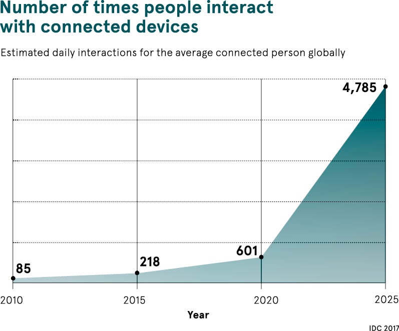
By 2025 the average connected person, anywhere in the world, will interact with connected devices nearly 4,800 times a day, or once every 18 seconds, analyst firm IDC predicts in its recent Data Age 2025 white paper. “The potential benefits of this vast quantity of data for city dwellers is enormous – improved air quality, reduced traffic and safer streets among them,” says Glenn Rogers, senior directer, Europe, Middle East and Africa, at Seagate Technology, the organisation that commissioned the research.
Indeed, the torrents of data – the primary driver of machine intelligence – are beginning to oil the transportation infrastructure of smart cities, where citizens now expect to flow to and between urban locations, using multiple modes of transport. In theory, the data harvested from an increasing number of sensors and other datapoints, blended with GPS technology, can provide real-time mapping to aid smoother inner-city travel.
The opportunities of so much data
Developments in data analysis may flash the green light for innovators and entrepreneurs, however complexities around legacy infrastructure and a long list of stakeholders competing for funding means the brakes of progress are being applied. In practice, then, the majority of cities are playing catch-up and failing to maximise the potency of emerging, data-hungry technologies.
Data harvested from an increasing number of sensors and other datapoints, blended with GPS technology, can provide real-time mapping to aid smoother inner-city travel
“There is a huge opportunity in this area,” enthuses Miranda Sharp, head of Ordnance Survey’s innovation and outreach department. “The amount of data available is exploding; data from mobile phones, smart tickets, CCTV cameras, engine-performance systems and from social media can be used by control systems in traffic lights, emergency services, and for making long-term decisions about routes and demand.”
TfL setting example for data sharing
As Londoners will attest, a seamless travel experience in the capital is some distance away, with overground and underground train delays, and standing traffic a near-daily frustration. Although it has rapidly improved in the last handful of years ever since the pioneering decision by Transport for London (TfL) to open, and make public, its data.
Now, according to Deloitte, some 42 per cent of London’s commuters use at least one of the 600-plus data-powered applications spawned from TfL’s data. These include the popular Citymapper and Waze, plus other journey planners, mapping, booking and scheduling tools, and analytics engines.
Deloitte’s study, published earlier this year, found that there are more than 80 TfL data feeds being used by over 13,000 registered developers, ranging from individuals to multinational tech organisations. Furthermore, the total value of open data to the organisation, customers and others is estimated to be £130 million a year.
At present more than 31 million journeys are made in London every day, and each one serves to improve the wider transport network, with data-fuelled artificial intelligence learning to spot patterns and predict trends. TfL recently analysed data from the free wifi provided in 97 per cent of its tube stations and in only four weeks had managed to reconstruct 42 million journeys through the network from five million distinct devices.
Ms Sharp holds up TfL as a “great example of how the data from an integrated transport system being made available gives rise to a number of consumer services that optimises routes and use of the network”. New ways of utilising data are being explored.
How data is powering smart city transport schemes globally
She continues: “Moovit, an Israeli company available in more than 2,500 cities across 82 countries around the world, takes a different approach, using data from mobile phones to create data feeds about transport to assist both consumers and the mix of public and private authorities that manage the transport to optimise the experience. And in Manchester and Dublin we are seeing the first examples of cycling infrastructure being built on the back of data produced by cyclists.”
Elsewhere, countless other data-driven smart city transport schemes are taking flight. They have, for instance, already uprooted Copenhagen’s public transport system – 40 per cent of commuters use bikes – and doubled the average speed of Singapore’s inner-city traffic. And in Helmond, a southern city in the Netherlands, Sweco UK’s cloud-based Smart Traffic system, which collects data from existing loop sensors and overlays it with GPS location data, is aiming to cut congestion. Simulations show the potential for 40 per cent reductions.
“In the future this will allow city authorities to give greater priority to public transport by introducing new initiatives such as ‘green-light phases’ at intersections during busy, rush-hour periods,” says Stephen Russell, Sweco UK’s director for transportation. “This technology will also form a key part of the infrastructure required to prepare for the advent of driverless cars. In a future where traffic signals are no longer needed, vehicles will use a cloud-based central traffic management system they can talk to that will provide every car, bus and tram with permission to cross a junction.”
Transport networks must collaborate to serve community of the future
Dr Nick Reed, head of mobility research and development at electronics giant Bosch, agrees. “Vehicle data is already informing mobility solutions of the future, as automated driving functions rely heavily on data collected through vehicle sensors for decision-making,” he says. His organisation has developed a community-based parking service that utilises data-sharing to guide drivers to available, out-of-sight spaces, saving around £500 in wasted time a year, while simultaneously reducing emissions and stress levels.
Jacqui Taylor, chief executive and co-founder of FlyingBinary, and a strategic adviser to the UK government on smart cities, warns: “By 2050, the global population is forecast to exceed nine billion, 80 per cent of which will inhabit cities.” While transport systems will be at the beating heart of tomorrow’s urban centres, she stresses that multi-stakeholder collaboration is imperative.
“Transportation networks in smart cities operate a multi-agency model that requires data and information technology services to be shared across many organisations,” Dr Taylor concludes. “These services form a part of the city-critical infrastructure that must support the expected significant increases in population. Hence the need now to use shared, not just open, data principles for transport infrastructure.”
The opportunities of so much data
TfL setting example for data sharing