Driven by developments in autonomy, connectivity and digitisation, the maritime industry is undergoing an exciting period of innovation and change.
This was a key focus of Maritime 2050, a strategy published earlier this year by the Department for Transport, which sets out the UK’s ambition to remain a world-leading maritime nation for the next 30 years.
For many of the recommendations made, spanning trade, technology and infrastructure, the strategy identified a common need for accurate and comprehensive data. And marine geospatial data, detailing the depth and nature of the marine environment, will have a significant part to play.
In the UK, the organisation responsible for collecting, processing and publishing this data is the UK Hydrographic Office (UKHO). First established over 220 years ago, the UKHO has a long history of charting the world’s oceans to help mariners navigate them safely. In fact, its portfolio of ADMIRALTY Maritime Data Solutions is currently used by more than 90 per cent of ships trading internationally.
Today, the organisation is using its expertise to enable an even greater understanding of the marine environment, to help those working across the blue economy to make use of the world’s oceans in smarter, more sustainable ways.
This includes helping coastal nations to achieve sustainable economic growth by using marine geospatial data to
support infrastructure, disaster resilience, resource management, tourism and responsible trade. Closer to home, they are working with UK government to increase the value of publicly held data by making it easier to access and use. And alongside
partners around the world, the UKHO is also using its expertise to help the maritime industry innovate.
Supporting ports of the future
Central to the maritime economy are ports, a sector undergoing huge advances in digitisation and connectivity. These advances promise to bring significant operational and environmental benefits to the shipping industry and beyond.
But to realise these benefits, operators and shipping companies need to be able to communicate efficiently ahead of each port call. For example, by sharing more accurate depth information, ships can take on more cargo. Or by sharing information about berth availability, operators can prevent unnecessary early arrivals and allow ships to sail slower, reducing fuel
consumption and CO2 emissions.
However, due to existing processes and contrasting terminology used across the industry, this critical information can be misunderstood and is often accessed at the last minute.
To help address this, the UKHO has been working with partners on the Port Call Optimisation Task Force to create a new universal data standard for all parties involved in a port call. Developed alongside industry leaders, including Maersk, Shell and the Port of Rotterdam, the standard has established a set of uniform terms for critical information such as depths, arrival and departure times.
This will enable port users to communicate more effectively, understand key information for each call and share it quickly across digital platforms. This change will dramatically improve the efficiency in ports, reducing costs and, importantly, given the sector’s current sustainability goals, reduce harmful greenhouse gas and local emissions.
“Our partnership with the UKHO is fundamental to the success of our mission to build a safer and more efficient framework for port call communications,” says Ben van Scherpenzeel, chairman of the task force. “The UKHO’s expertise and network has been vital to ensuring the global industry is aligned. And by working together we’ve taken an important first step towards realising the benefits of this new data standard.”
Setting foundations for autonomous shipping
Another significant development in the maritime sector is autonomous shipping. The possibility of partially or fully
autonomous vessels has captivated the maritime industry, promising to be nothing short of transformative.
In fact, the UKHO estimates by 2030 the global autonomous shipping sector will be worth a staggering £111 billion, employing 554,000 people. And key to unlocking these opportunities is ensuring autonomous vessels can use accurate and up-to-date data to navigate safely.
This was the focus of a pioneering research project in which the UKHO recently participated, in partnership with L3Harris and the Maritime and Coastguard Agency. Funded by the Department for Transport’s T-TRIG grant, the project identified the future data requirements for autonomous technology and how marine geospatial data can be used to enable the safe
navigation of unmanned vessels.
One particular area examined how navigational datasets could be repurposed into smart charts that can be interpreted by a computer, without the need for an on-board crew. In addition to navigational data, these charts could incorporate other key datasets, including tidal information, radio signals, maritime regulations and more.
While there is still a way to go before prototypes are realised, these findings will be an important part of establishing safe and efficient autonomous shipping in the UK.
Making marine geospatial data easier to access and use
As innovation brings new and exciting opportunities, so too does it bring new challenges that require comprehensive marine geospatial data to address. To help, the UKHO is working to increase the data it holds, as well as make it more accessible and valuable for marine data users.
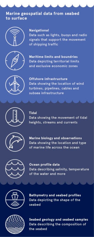
One such example is its ADMIRALTY Marine Data Portal. Launched earlier this year, the portal provides a single platform for users to access and download a wide variety of marine data sets. Continuously expanding, this includes bathymetry, wrecks and maritime limits, as well as the position of offshore infrastructure such as wind farms and pipelines – all of which are essential to decisions concerning the marine environment.
In addition to this, its data science team are also developing new ways to gather and use data to monitor environmental change. This recently involved the development of a new method to help map and monitor changes to mangroves: a tree species found in coastal areas with enormous capacity for absorbing greenhouse gases.
And recognising the increasingly flexible, digital working environment for shore-based users in the maritime industry, the UKHO has established an online version of its ADMIRALTY Vector Chart Service to support a range of tasks, from vessel tracking to accident and emergency incidents.
These are just some of the ways in which the UKHO is using its data and expertise to support international trade and others in a changing world. But alongside good data, fundamental to innovation within the maritime industry are strong partnerships. To help realise the benefits of safe, sustainable and more advanced operations, the UKHO is continuing to work closely with industry and partner organisations to enable technological advancements.
And by making its data more discoverable, interoperable and fit for purpose, the UKHO is proudly supporting the global maritime industry for the future.
For more information please visit admiralty.co.uk/ukho/about-us
