So what do we mean by blue economy? Namely, the sustainable use of ocean resources for economic growth. And according to the UK government’s chief scientific adviser in the Foresight Future of the Sea Report, the gross value added of the blue economy is projected to double to $3 trillion by 2030.
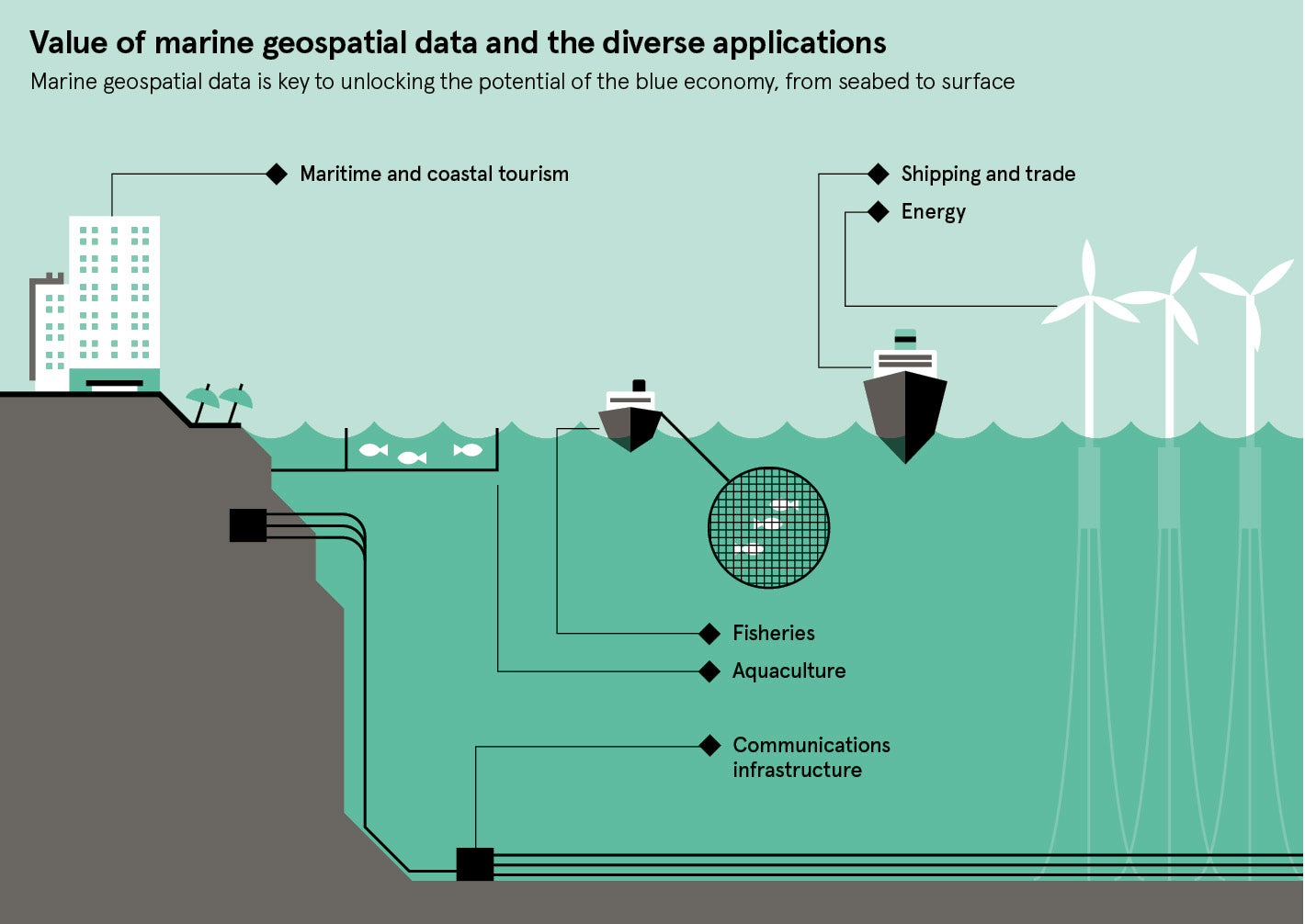
This value exists in industries such as trade, tourism, aquaculture and renewable energy. But it is also dependent on the sustainable use of these marine resources to protect our oceans and the people who rely on them.
Underpinning all this activity is marine geospatial data on safe shipping routes, deep-sea biodiversity, movement of the seabed and more. This also includes bathymetry, the underwater version of topographic mapping.
Here in the UK, the organisation responsible for the collection and analysis of this data is the UK Hydrographic Office (UKHO).
At its core, the organisation supports the defence of the UK and the safe passage of ships in UK waters. They do this by making the latest data available to the Royal Navy and merchant mariners to protect lives at sea.
The UKHO also uses its wealth of marine data to create commercial value on a global scale. More than 90 per cent of all ships trading internationally rely on the navigational charts, publications and digital services made available under its ADMIRALTY Maritime Data Solutions brand.
But its repository of data contains so much more than just navigational information; water salinity, maritime boundaries, marine mammals and tides are just some of the datasets processed by the organisation. It’s this wealth of data that’s being used to help others create sustainable economic growth and support decision-making across the globe.
A key example of this is the work carried out through the Commonwealth Marine Economies Programme, an initiative being delivered by the UKHO and government partners on behalf of the Foreign & Commonwealth Office, which aims to unlock a £2-billion return for 17 nations across the Caribbean and Pacific.
Harnessing marine resources can bring huge benefits for these nations, from improving trade to protecting the marine environment. This, in turn, can create jobs, reduce poverty and build resilience against environmental challenges such as natural disasters and climate change.
A nation to benefit from the programme is the coastal nation of Guyana, where export trade was previously limited by the poor quality of navigational information available. The UKHO captured information on seafloor features, depths and currents, as well as navigational aids such as lights and buoys, all of which will be used to update ADMIRALTY charts of the area. With the second lowest per capita income in the Caribbean region, these charts are expected to provide a catalyst for long-term, sustainable economic growth through increased trade.
Another example is the Caribbean island of Grenada, where its marine area is 75 times larger than its land mass, so it is largely reliant upon its marine resources. UKHO teams conducted high-resolution bathymetric surveys to capture data of the marine environment, enabling islanders to use their marine resources more effectively and sustainably.
Data collected in these areas can also be used to inform important decisions around coastal protection, disaster modelling and crisis response. This became particularly visible in the aftermath of Hurricane Irma, which struck in August 2017, affecting a number of nations including the British Virgin Islands, a UK Overseas Territory. Using satellite imagery and basic soundings, UKHO staff processed data to create and supply special-purpose emergency charts in under 48 hours to support UK relief efforts. As a result, aid and medical supplies could be delivered as quickly and safely as possible by sea.
We have seen first hand how accurate marine geospatial data can contribute to the dual aims of marine protection and development of the blue economy
Whether in the Caribbean or the UK, the UKHO is using its technical expertise and global network of partnerships to meet a growing range of maritime needs. It is continuing to invest in its capabilities, so wider sets of data can be processed, accessed and used in smarter ways, unlocking even greater value to the global economy.
All this work is part of the UKHO’s broader transformation into a Marine Geospatial Information Agency, a digital-first, data-centric provider of marine geospatial information services.
At the heart of this transformation is a new data science team, new data platform and new appetite for technology.
One particularly eye-catching innovation from the organisation is a bespoke artificial intelligence system for automated offshore object detection. This system employs open-source radar satellite imagery, a “blob detection” algorithm (that really is the technical term) and deep-learning to detect unidentified objects visible in the ocean.
Since it went live in June, the system has processed satellite imagery covering almost 900,000 sq km of ocean, detecting 342 hazards previously unknown to the organisation, which are now highlighted in ADMIRALTY charts and publications. As a result, the risk of maritime incidents diminishes, while our understanding of the marine environment deepens.
Further innovation at the UKHO has led to the creation of a new ADMIRALTY Tidal API (application programming interface), offering predictions on high and low-tide times from its vast database of tidal information. This is enabling software developers to build UK tidal data into their
own apps.
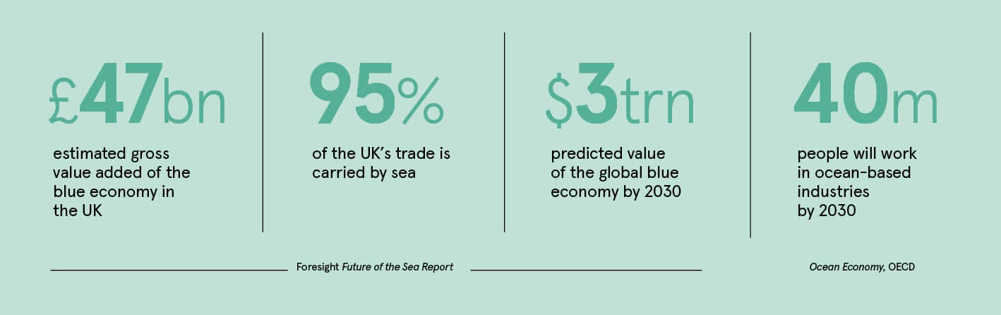
This forward-thinking approach to technology and data science is now being recognised across government. It was announced last year that the UKHO will be a key partner in the newly formed Geospatial Commission. This aims to drive economic growth by maximising the value of all location-based data in the UK, unlocking up to £11 billion of extra value for the UK economy a year. And much of that value lies out there in the blue.
“We have seen first hand how accurate marine geospatial data can contribute to the dual aims of marine protection and development of the blue economy,” says John Humphrey, the UKHO chief executive. “We will continue to enable governments and companies to make critical maritime decisions, both in the UK
and worldwide.”
With its impressive repository of data, combined with the tools, expertise and global relationships to use it, the UKHO is enabling sustainable growth of the blue economy.
Marine geospatial data not only has the potential to unlock a wealth of economic benefits for developed and developing nations alike, but is the key to unlocking a deeper understanding of the world’s oceans.
For more information please visit admiralty.co.uk
